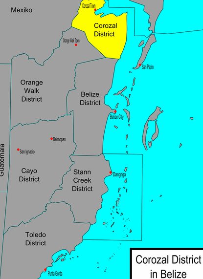
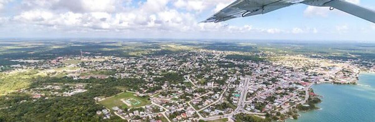
COROZAL DISTRICT
Why consider vacationing in Corozal?
Travelers and retirees love it here because Corozal is off the tourist track and, with everything from sport fishing to ancient Maya Temples to the Shipstern Nature Reserve, there’s plenty to do.
The northernmost district (state) in the country, Corozal has long been overlooked by most tourists, although that is beginning to change. Near the district’s capital of Corozal Town can be found the Maya ruins of Santa Rita and Cerros. The ruins now known as Santa Rita once controlled vital trade routes between present-day Mexico and Guatemala.
For most of Corozal’s modern history, the region was best known for its agriculture, particularly the sugar cane crop. Now that tourists have begun to explore this beautiful area, Corozal has become a leading site for eco-tourism, with visitors flocking to the fishing villages of Consejo and Sarteneja to experience an authentic taste of local life in Belize.
Corozal is also becoming a popular haven for expats and retirees from America and around the world, drawn to the town by its sleepy charm and easy access to affordable goods, high-quality medical care, and shopping opportunities just across the border in Mexico.
THINGS TO DO - COROZAL DISTRICT
|
Top Attractions in Corozal Belize
|
Getting to Corozal
Most international visitors to Corozal first fly to Belize City at the Phillip Goldson International Airport. From there, taxis or shuttles can take you to any location in Corozal District. For visitors coming in overland from Chetumal City in Mexico, public transportation on so-called “chicken buses” is the only option, which offer little in the way of comfort, but ticket prices are extremely affordable. |


Things To See & Do In Corozal District
Visitors are recommended to visit the nearby Mayan ruins of Cerros and Santa Rita. Cerros is located in the Bay of Chetumal, right on the coast, the only Mayan city in the world with an oceanfront view. It’s still possible to climb the steep steps of the main temple, offering visitors an unparalleled view of Chetumal, the New River, and the panorama of the Corozal District.
Another popular local attraction is visiting the fishing village of Sarteneja. Originally built by the Maya, it is now the largest fishing village in the country, home to locals who still fish the rich waters in small boats.
Birdwatchers will enjoy a trip to the Shipstern Nature Reserve, over 27,000 acres of unspoiled territory. The nature reserve is home to all five of Belize’s wild cat species, as well as more than 300 species of birds, including the endangered Baird’s Tapir.

What To Eat & Drink In Corozal District
Local Belizean delicacies and snacks are also popular in Corozal, and visitors can explore the local markets to get the best in fresh produce and seafood. Roadside vendors sell some of the best fresh juice in the country, popular with locals and visitors alike.
Where To Stay In Corozal District (Where To Stay)
Since Corozal is only just now being discovered by tourists, there are no large hotel chains or luxury accommodations. Quality lodgings can be found at the numerous family-owned small hotels and inns clustered on the coast or in the southern part of Corozal.
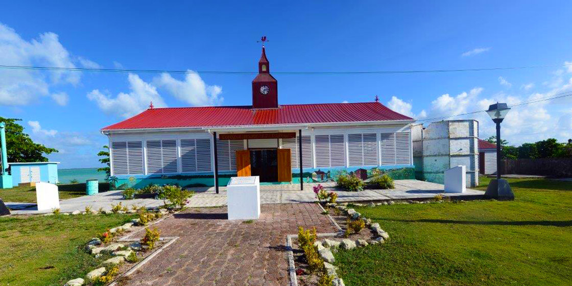
COROZAL HOUSE OF CULTURE
Corozal House of Culture
Just off the Corozal Bay, the House of Culture is housed in what was once the community center point of Corozal Town. Corozal House of Culture, with its signature clock tower, was originally built as the Municipal Market in 1886 and served as the town's market for one century. This House of Culture has now been transformed to include a museum, art gallery. It acts as the Community Center, hosting at least two cultural events monthly.
Located in the heart of Corozal Town in northern Corozal District, the Corozal House of Culture serves as the perfect introduction to the area’s long and colorful history.Originally built to serve as the town’s market in 1886, the Corozal House of Culture (known to locals simply as “Corozal House”) is now a combination museum, art gallery, and community center. Renovated and transformed into the Corozal House of Culture, the building is operated by Belize’s National Institute of History and Culture (NICH) which also manages several other museums and ancient Maya archeological sites across the country.
The official address of the Corozal House of Culture is First Avenue just a few paces from the beaches of Corozal Bay, but the unique design and prominence of the building make it quite easy to find from just about anywhere in Corozal Town. The Corozal House of Culture is open Monday through Friday from 8:00 a.m. to 5:00 p.m. with free admission for everyone. The Corozal House of Culture does not maintain its own website, but you can get contact information as well as information about upcoming exhibitions and cultural events by visiting their Facebook page.
The Corozal House of Culture regularly hosts cultural events such as dance workshops, folk singing exhibitions, book launches, art exhibitions, and poetry readings. But the main attraction is the museum which documents more than 3,000 years of life in Corozal District that includes exhibits from the time of the ancient Maya and information about the failed Spanish attempts at colonization, the Mexican Caste War of the 19th century, the British colonial period, and the modern era of Belizean independence.
The Maya people have been living in Corozal District for approximately 3,000 years. In Corozal Town, visitors can explore the ruins of Santa Rita which was once an important coastal trading site for the Maya. In the 17th century, the Spanish struggled to control the Maya and many of the Catholic churches they built were burned down as the Maya were constantly revolting. In the mid-19th century, a war in nearby Yucatan, Mexico saw thousands of indigenous people (known locally as “Mestizos”) emigrate to Corozal District.
The warm climate and fertile soil make Corozal District ideal for growing crops such as sugarcane, but in the past few decades, the district has diversified by developing its tourism industry and growing other crops such as papayas and citrus fruits.
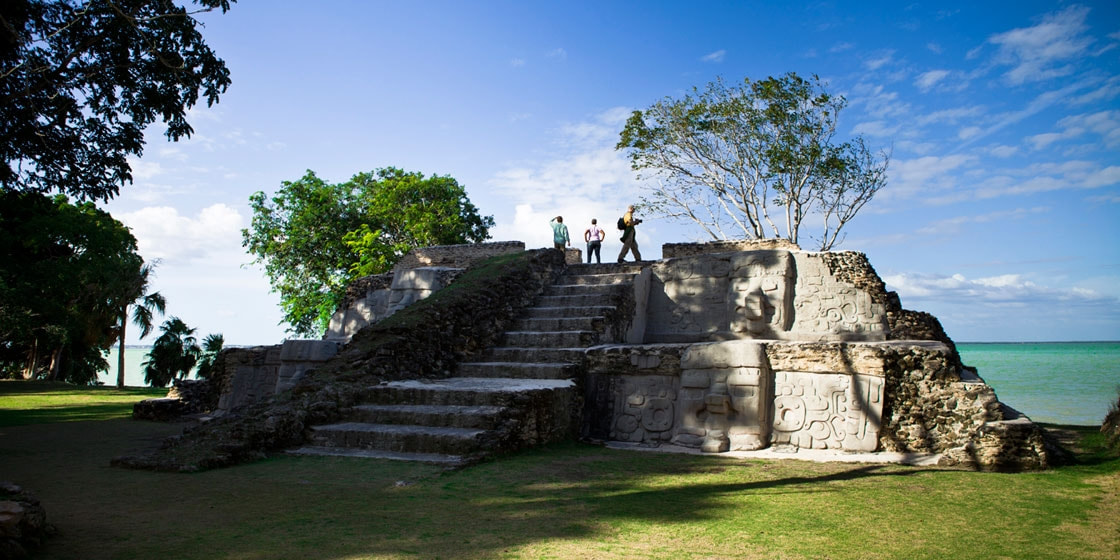
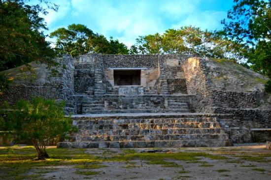
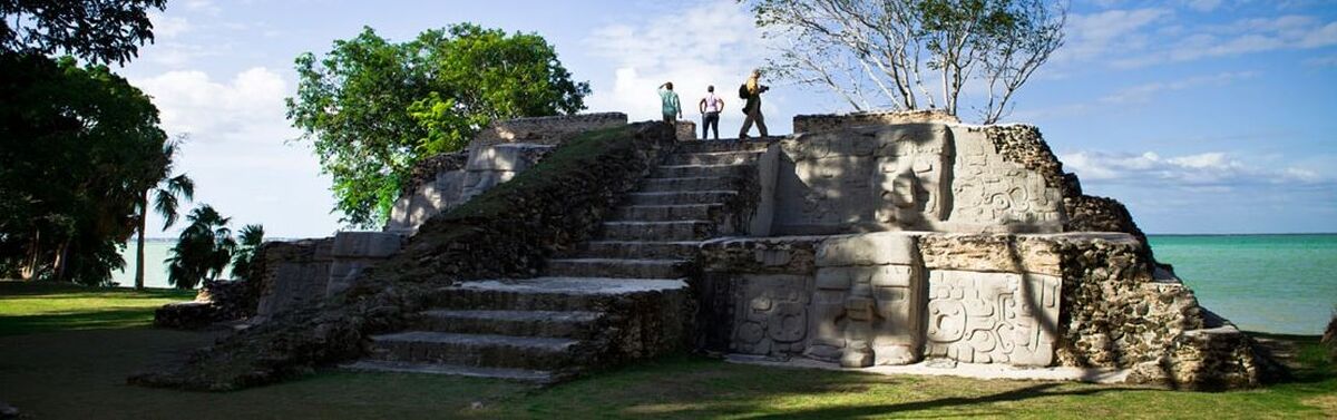
SANTA RITA MAYAN TEMPLE
Santa Rita Mayan Temple
Santa Rita ruins is a Maya ruin and an archaeological reserve on the outskirts of Corozal, Belize. Historical evidence suggests that it was probably the ancient and important Maya city known as Chetumel.
The modern town of Corozal was founded in 1848 by refugees from the Caste War in neighbouring Yucatán, and expanded steadily making it the major ethnicity in the country at the time. The ruins of Santa Rita became a target for building resources; the mounds of the site made convenient road fill and the stones were used for structure foundations. Because of this, the exact borders of the ancient Mayan city may never be known.
In the early 1900s, amateur archaeologist Thomas Gann visited the site and discovered a Mixtec-influenced mural; these do not survive, but copies made by Gann do. No substantial research followed this until the Corozal Postclassic Project, led by Arlen Chase and Diane Zaino Chase, carried out a series of excavations between 1979 and 1985.
Little structural evidence remains from the Postclassic era. The only existing structure at the ruins dates from the Classic era. The centre of this building has been described as a ceremonial chamber, with a complex series of interconnected passages leading to other rooms, including two burial chambers. One contained the remains an elderly woman surrounded with jewellery and pottery; the other was that of a warlord, evident from the artefacts found buried with him — a ceremonial flint representing leadership and a stingray spine most used in blood-letting rituals. Both burials date from around 500 CE.
Artifacts found dating from the Postclassic era reveal that religious rituals like blood-letting, which were very important during the Classic era, continued to play an important role. The presence of items of Aztec origin, also dating from the Postclassic period, attest to the continuing trade importance of Santa Rita several hundred years after the decline of the major ceremonial centres of the interior.
CERROS MAYAN TEMPLE
Cerros Mayan Temple
Cerros is an Eastern Lowland Maya archaeological site in northern Belize that functioned from the Late Preclassic to the Postclassic period. The site reached its apogee during the Mesoamerican Late Preclassic and at its peak, it held a population of approximately 1,089 people. The site is strategically located on a peninsula at the mouth of the New River where it empties into Chetumal Bay on the Caribbean coast. As such, the site had access to and served as an intermediary link between the coastal trade route that circumnavigated the Yucatán Peninsula and inland communities. The inhabitants of Cerros constructed an extensive canal system and utilized raised-field agriculture.
Archaeological work began at Cerros around 1973 when the site was purchased by the Metroplex Corporation of Dallas, who intended to build a tourist resort around the ceremonial center, and to eventually donate the archaeological site to the Government of Belize for a National Park. They contacted Dr. Ira R. Abrams, who was teaching in Dallas in the Anthropology Department of Southern Methodist University (SMU), and had extensive experience working with the Maya in that part of what was then British Honduras (it became the independent country of Belize in 1981).
Abrams worked with Metroplex President John Love, and their employee John Favro and local arts patron Stanley Marcus create the Cerro Maya Foundation to fund excavations and the partial restoration of the site, through the Department of Anthropology at SMU. To accomplish this, Abrams became Director of the Cerro Maya Project and Member of the Board of the Cerro Maya Foundation, and hired archaeologist Dr. David Freidel to supervise the excavations. Abrams also made initial arrangements with Dr. Joseph Palacio, the Archaeology Commissioner of British Honduras for a permit to excavate the site and hired workers from Xaibe Village to work at the site.
When plans for the proposed resort failed, the site was given to the government of Belize as promised. In 1974, archaeologist David Freidel and his team uncovered evidence that suggested that the site was of the Late Preclassic period. In 1975, when a dedicatory offering cache was uncovered at Structure 6, further evidence was provided that Cerros was indeed a Late Preclassic site.
Throughout the 1970s, research was allowed to continue when the National Science Foundation funded further excavations. The original team completed their excavations in 1981.
In the 1990s, Debra Walker and a team of archaeologists began a series of new excavations to investigate the site's demise at the end of the Late Preclassic Era. In addition to the research done at the site, Walker's team also had radiocarbon dates run on newly found artifacts. They also recalibrated several dates from the original research in order to establish a tighter chronological sequence.
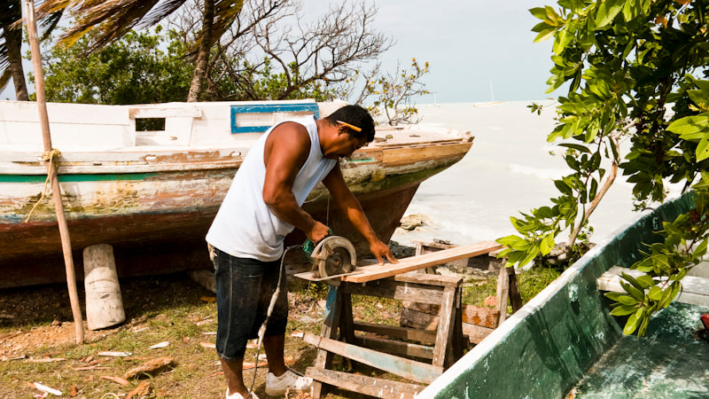
SARTENEJA
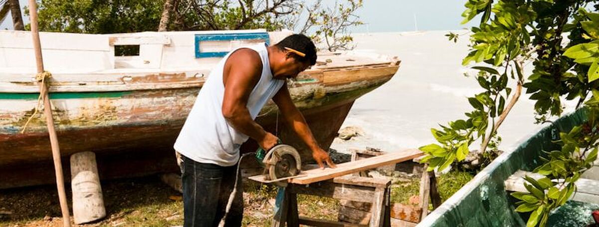
Sarteneja
This remote village of fisherman and boat builders is the perfect off-the-beaten-path destination for curious travelers. Located in the far north of the country in Belize’s Corozal District, Sarteneja is officially the country’s largest village with approximately 4,500 inhabitants. From a Mayan name meaning “water between the rocks,” the village has several freshwater wells. First settled by the Maya more than 2,600 years ago, today the village is home to a mixture of Mexican migrants from the nearby Yucatan peninsula, expats from North America, and descendants of the ancient Maya.
Why You Have to Visit Sarteneja Belize on Your Vacation?
Due to Sarteneja’s position on the Bay of Corozal, it is the only place in Belize where you can watch the sun set over water. Still the home of fisherman and lobstermen, the village is also renowned for its artisan boat builders. Another important local industry is pineapple farming.
Where in Belize Is it Located?
Sarteneja is located in the northeastern tip of Corozal District in northern Belize approximately 40 miles north of Orange Walk Town.
When is the Best Time to Visit Sarteneja Belize?
While a visit to Sarteneja is rewarding at any time of the year, the village has a special celebration on November 1 and 2. Called “All Souls’ Day” in English and “Dia de los Muertos” in Spanish, November 1 is the day when the villagers of Sarteneja say special prayers and leave food out in the belief that deceased children have crossed over and become angels and will return to visit their relatives and loved ones. The following day is marked by prayers and food offerings for adult family members who have died, with each relative’s favorite dish being prepared in order to welcome them back for their brief visit.
Best Way to Get to Sarteneja Belize.
Tourism is only starting to discover Sarteneja so there aren’t many connections to this remote village. From Orange Walk Town, it’s about an hour or so over smaller roads to traverse the 40 miles to the village of Sarteneja. You can also arrive by water taxi (Thunderbolt Water Taxi) from either Corozal or Ambergris Caye.
Best Way to Experience Sarteneja Belize.
With gorgeous beaches, pristine water and a protected ecosystem, Sarteneja is an ideal destination for anyone who wants to enjoy swimming, bird watching or fishing. As the only location in Belize in which to observe the sun set over water, it’s worth a trip to Sarteneja just to experience this magnificent sight.
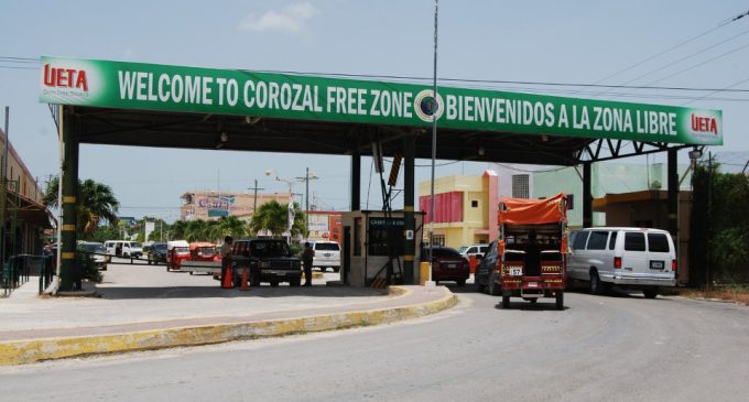
MEXICO BOADER - COROZAL
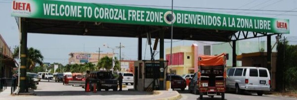
Mexican Boarder - Corozal, Belize
Corozal shares a strong historical connection with our Mexican neighbors, and is the birthplace and home of the Mestizos (Maya and Spaniard culture). Today, the district encompasses a diverse population of ethnic backgrounds that have blended to give the people a distinctively relaxed outlook on life, making Corozal a tranquil paradise. The warm and welcoming locals makes this haven the perfect getaway destination.
Located 89 miles north of Belize City and only 7 miles from the Mexican border, the town has a population of almost 10,000. Corozal is a haven for retirees from Europe and North America, but don’t feel like you have to take things slow here.
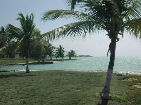
CONSEJO VILLAGE
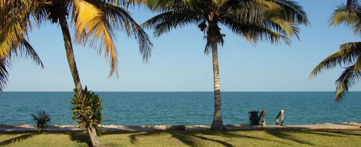
Consejo Village & Consejo Shores
Consejo Village is the northern most settlement in Belize. Nestled on the shore of Chetumal Bay, Consejo is 7 miles north of Corozal Town and 2 miles south across the bay from Chetumal, Mexico (pop. 290,000). There are no Malls, movie theaters, fast food places, large hotels or the other trappings of developed resorts in Consejo. Most of those things are, however, available close by in Chetumal, just a 9 mile drive or a quick boat ride away.
Consejo is a very quiet, peaceful and beautiful place. Belizeans, retirees and tourists enjoy its serenity. There are several small expatriate communities near Consejo Village, including Consejo Shores, Wagner's Landing (home of Smuggler's Den) and Mayan Seaside.
COROZAL TOWN
Corozal Town
Corozal Town proper is definitely go slow and easy going. Eclipsed by the bustling neighbor of Chetumal City, Corozal has devolved into a sedentary town that is well maintained and well laid out. Most of the town was destroyed by a hurricane in 1955, and before being rebuilt, streets and avenues were properly laid out making it one of only two municipal centers in Belize (the other is the City of Belmopan) with reasonably wide streets and good drainage.
Corozal Town is a convenient base for day trips to Chetumal, the capital of Mexico’s southern state of Quintana Roo which is nine miles away, or for excursions to the Maya ruins and beaches of the Yucatan Peninsula. San Pedro Ambergris Caye, the most popular destination for scuba divers and snorkelers, is only 15 minutes by air from the Corozal airstrip. It is 90 miles from Belize City to Corozal by road and buses run daily. Corozal is located between two scenic rivers, the New River in the Orange Walk District and the Rio Hondo that forms a natural boundary with Mexico. The district has its fair share of Maya ruins, boating, nature trails, swimming and fly fishing attractions.
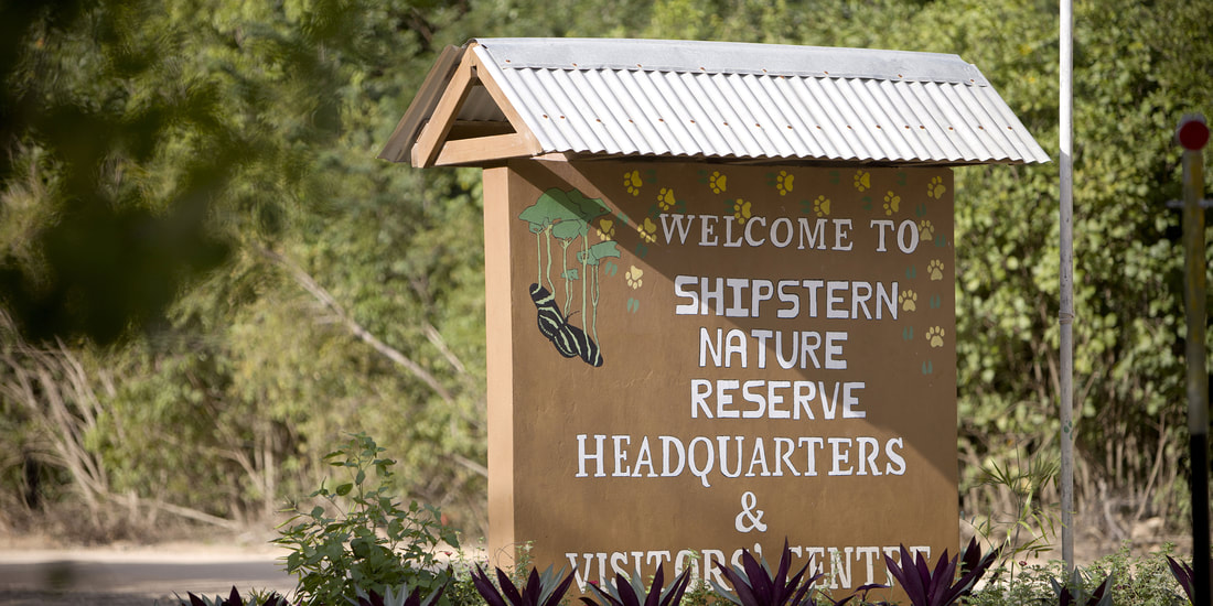
SHIPSTERN NATURAL RESERVE
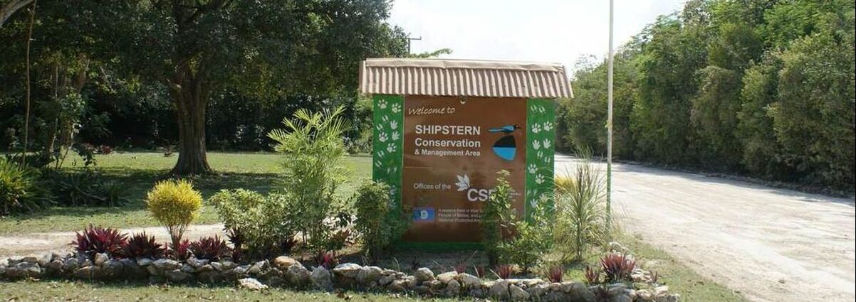
Shipstern Nature Reserve
Currently officially known as the Shipstern Conservation and Management Area, Shipstern is a large area of land of 21,500 acres in Belize’s northern Corozal District. Although not contiguous in design, Shipstern is centered on the Shipstern Lagoon, one of the largest inland lagoons in the country. The conservation area is designed to protect rare forest trees, including seasonal and dry coastal tropical varieties.
Why You Have to Visit Shipstern Nature and Wildlife Reserve on Your Vacation?
Although Shipstern is owned and managed by a private NGO, the Belizean government considers the reserve to be one of the top 10 most important sites of its kind in the country. Shipstern is most famous for its large variety of birds that make their home in the reserve, at least 300 in total, including egrets, parrots, warblers, flycatchers, toucans and American coots. The reserve is also home to raccoons, pumas, deer, peccaries, armadillos, tapirs, crocodiles, manatees and jaguars. One of the most popular attractions in Shipstern is a butterfly farm adjacent to the visitor center where butterflies are being bred for trade with the United States, Europe and Asia.
Where in Belize Is Shipstern Nature and Wildlife Reserve Located?
The entrance to Shipstern is 3.5 miles (6 km) from the village of Sarteneja in Corozal District.
When Is the Best Time to Visit Shipstern Nature and Wildlife Reserve?
The Butterfly Breeding Center is open from 9:am to 12:00 and 1:00 pm to 4:00 pm daily. The reserve is only open during daylight hours but night hikes can be arranged with permission from Shipstern.
Best Way to Get to Shipstern Nature and Wildlife Reserve.
From the village of Sartaneja, it’s possible to walk to the reserve. There is also a daily bus that leaves Belize City to Sartenaja, with a stop at Orange Walk Town. By car, Shipstern is one hour from Orange Walk Town and two hours Belize City. Due to seasonal variations and road quality, only four-wheel-drive vehicles are recommended.
Best Way to Experience Shipstern Nature and Wildlife Reserve.
Start at the visitor’s center at the entrance to the reserve and then visit the nearby butterfly center, home to more than 200 species. From there, visitors can follow the well-marked Chiclero Botanical Tool to see a variety of medicinal plants and the birds, amphibians and mammals that inhabit the reserve. Guided tours of the reserve are available for a fee.