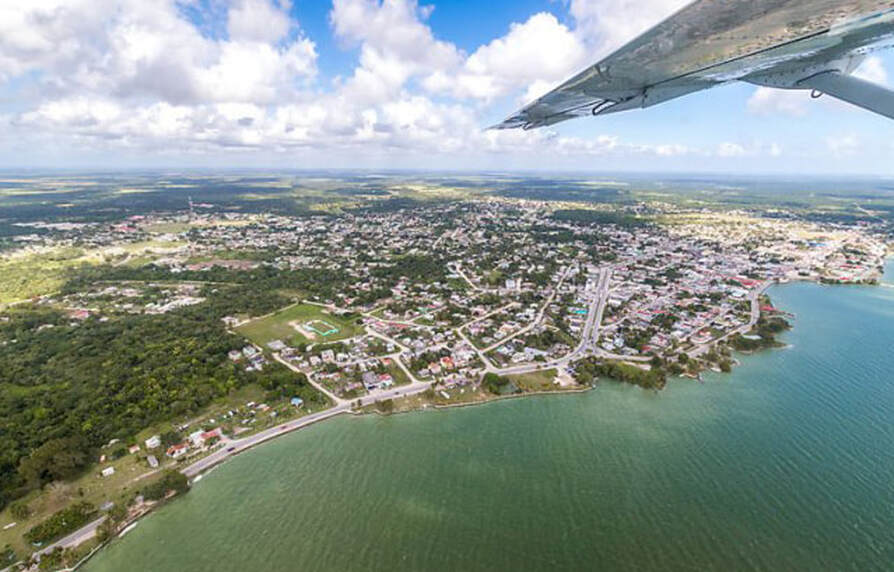
ABOUT COROZAL DISTRICT
The Corozal District is the northermost area of Belize. For many Belizeans it is the gateway to Mexico, but the peaceful towns, villages and landscape of the surrouding area offers much more. The area is alive with culture, history and wildlife. The district capital is the city, Corozal Town. Corozal District also as the following towns and villages: Chunox, Consejo, Little Belize, Louisville, Patchacan, Progresso, San Joaquin, and Xaibe.
While the island of Ambergris Caye may geographically be closest to Corozal District, it is actually a part of the Belize District. The Pre-Columbian Maya ruins are found in Corozal at Santa Rita near Corozal Town, at Louisville, and at Cerros.
The name Corozal comes from the Maya Yucatecan name for the Chune Palm, which grows wild in the area. These trees were considered by the Maya to be symbols of fertiility, which is a fitting name for the area of Belize that is arguably the most agriculturally productive of the country. The main crops are corn and sugar-cane, which provide livelihoods for many of Corozal Town's residents. Corn plays a major role in all local dishes, tortillas, tamales, tamalitos.
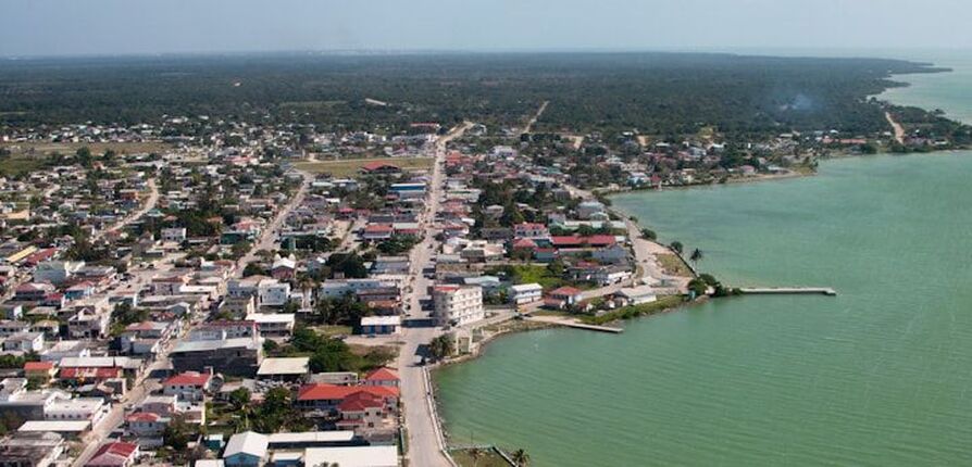
Located 84 miles from Belize City and 8 miles from Mexico, the town of Corozal lies on the foundations of the ancient Maya ceremonial center of Santa Rita on the banks of Chetumal Bay. Santa Rita is one of the earliest Maya settlements in the north dating from 2000 BC. Excavation of the site yielded pottery of the Swasey style, some of the earliest ot be found in the Maya area. The city also controlled the trade through the Rio Hondo and New River. The area remained populated with Maya until the late 16th century after which the city began to decline.
In 1848 and 1849 as a result of the Caste Wars (La Guerra de las Castes) in Mexico, thousands of Maya and Mestizo refugees from southern Mexico made this area their home. Today, the Mestizo continue to be dominant. Many traditions remain - most residents speak Spanish and are Catholic.
The town is laid out in the traditional Mexican grid system with activities centering around the town square. In two corners of the plaza there are the remains of small forts built to ward off Indian attacks. The original town was made up of adobe and thatch houses, but in 1955, Hurricane Janet devastated the town and only 10 houses remained. One house still stands proud, and excellent example of the old style of architecture. In town hall, a 1953, mural by artist Manual Villamor Reyes depicts the diverse history of the region and is constantly being updated and expanded.
Historically, the entire area plays an important part in the story of the Maya civilization with an abundance of unexcavated mounds and artifacts. Cerros, which can be seen from Corozal town, has a spectacular setting on the coast overlaying Chetumal Bay. The site covers 53 hillside acres and was an important late pre-classic trading post for jade and obsidian. The partially excavated 70-foot temple, with its intricate stucco masks representing the rising and setting sun, overlooks the sea. It's easy for visitors to imagine what it would have been like thousands of years ago to watch your friends and enemies approaching.
You can take a 20-minute boat ride from Corozal to Cerros, or, by land, you will need to cross the New River on the hand-cranked ferry. Either way, Cerros is definitely worth the visit.
Nearby is the sleepy fishing village of Copperbank, named by the English who arrived in 1877, after some copper coins were found. A beautiful tranquil setting on the Laguna Seca with an abundance of flowers and fruit trees make this hidden paradise worth a visit. Three nearby lagoons, including the idyllic Progresso Lagoon, are home to crocodiles, manatees, agouti, tapir, woodpeckers, toucans, and countless other jungle birds.
On the shores of Chetumal Bay lies yet another tranquil fishing village, Sarteneja. The name with its Maya meaning of "water between rocks" refers to the huge stone well run dry. The main industry here is commercial fishing. Fishermen here use the traditional wooden "lighter" boat (a boat historically used for transferring cargo from a large ship to the bank) to sail as far south as Guatemala and Honduras in search of conch, lobster, shrimp and fish. Holding up to 15 men, these sailing boats are a beautiful and frequent sight up and down the coast of Belize. When the icy supply becomes low, they begin the return journey and often sell their catch in Belize City and San Pedro on the way home.
Every Easter, an annual sailing regatta is held in the Sarteneja harbor, in recent years, Sartenjea has gained popularity with tourists for freshwater fishing in the lagoons rich in tarpon, snook, cubera snapper and jewfish.
The Shipstern Nature Reserve, three miles from Sarteneja, covers over 32 quare miles of unspoiled jungle, sabvanna and mangrove swamp. This protected area is now under the control of the Belize Audubon Society, and is home to an atosnishing diversity of wildlife. All five cats living in Belize can be found here along with the tapir, armadillo, peccary, coatimundi, manatee and crocodile among others The birdlife is incredible with over 200 species including hte reddish egret, while-winged dove, yellow lored parrot, black catbird and Yuvatan jay.
Corozal District is the northernmost district of the nation of Belize. The district capital is the city, Corozal Town. Corozal District also as the following towns and villages: Chunox, Consejo, Little Belize, Louisville, Patchacan, Progresso, San Joaquin, and Xaibe.
While the island of Ambergris Caye may geographically be closest to Corozal District, it is actually a part of the Belize District. The Pre-Columbian Maya ruins are found in Corozal at Santa Rita near Corozal Town, at Louisville, and at Cerros.
While the island of Ambergris Caye may geographically be closest to Corozal District, it is actually a part of the Belize District. The Pre-Columbian Maya ruins are found in Corozal at Santa Rita near Corozal Town, at Louisville, and at Cerros.
The name Corozal comes from the Maya Yucatecan name for the Chune Palm, which grows wild in the area. These trees were considered by the Maya to be symbols of fertiility, which is a fitting name for the area of Belize that is arguably the most agriculturally productive of the country. The main crops are corn and sugar-cane, which provide livelihoods for many of Corozal Town's residents. Corn plays a major role in all local dishes, tortillas, tamales, tamalitos.
Located 84 miles from Belize City and 8 miles from Mexico, the town of Corozal lies on the foundations of the ancient Maya ceremonial center of Santa Rita on the banks of Chetumal Bay. Santa Rita is one of the earliest Maya settlements in the north dating from 2000 BC. Excavation of the site yielded pottery of the Swasey style, some of the earliest ot be found in the Maya area. The city also controlled the trade through the Rio Hondo and New River. The area remained populated with Maya until the late 16th century after which the city began to decline.
In 1848 and 1849 as a result of the Caste Wars (La Guerra de las Castes) in Mexico, thousands of Maya and Mestizo refugees from southern Mexico made this area their home. Today, the Mestizo continue to be dominant. Many traditions remain - most residents speak Spanish and are Catholic.
The town is laid out in the traditional Mexican grid system with activities centering around the town square. In two corners of the plaza there are the remains of small forts built to ward off Indian attacks. The original town was made up of adobe and thatch houses, but in 1955, Hurricane Janet devastated the town and only 10 houses remained. One house still stands proud, and excellent example of the old style of architecture. In town hall, a 1953, mural by artist Manual Villamor Reyes depicts the diverse history of the region and is constantly being updated and expanded.
Historically, the entire area plays an important part in the story of the Maya civilization with an abundance of unexcavated mounds and artifacts. Cerros, which can be seen from Corozal town, has a spectacular setting on the coast overlaying Chetumal Bay. The site covers 53 hillside acres and was an important late pre-classic trading post for jade and obsidian. The partially excavated 70-foot temple, with its intricate stucco masks representing the rising and setting sun, overlooks the sea. It's easy for visitors to imagine what it would have been like thousands of years ago to watch your friends and enemies approaching.
You can take a 20-minute boat ride from Corozal to Cerros, or, by land, you will need to cross the New River on the hand-cranked ferry. Either way, Cerros is definitely worth the visit.
Nearby is the sleepy fishing village of Copperbank, named by the English who arrived in 1877, after some copper coins were found. A beautiful tranquil setting on the Laguna Seca with an abundance of flowers and fruit trees make this hidden paradise worth a visit. Three nearby lagoons, including the idyllic Progresso Lagoon, are home to crocodiles, manatees, agouti, tapir, woodpeckers, toucans, and countless other jungle birds.
On the shores of Chetumal Bay lies yet another tranquil fishing village, Sarteneja. The name with its Maya meaning of "water between rocks" refers to the huge stone well run dry. The main industry here is commercial fishing. Fishermen here use the traditional wooden "lighter" boat (a boat historically used for transferring cargo from a large ship to the bank) to sail as far south as Guatemala and Honduras in search of conch, lobster, shrimp and fish. Holding up to 15 men, these sailing boats are a beautiful and frequent sight up and down the coast of Belize. When the icy supply becomes low, they begin the return journey and often sell their catch in Belize City and San Pedro on the way home.
Every Easter, an annual sailing regatta is held in the Sarteneja harbor, in recent years, Sartenjea has gained popularity with tourists for freshwater fishing in the lagoons rich in tarpon, snook, cubera snapper and jewfish.
The Shipstern Nature Reserve, three miles from Sarteneja, covers over 32 quare miles of unspoiled jungle, sabvanna and mangrove swamp. This protected area is now under the control of the Belize Audubon Society, and is home to an atosnishing diversity of wildlife. All five cats living in Belize can be found here along with the tapir, armadillo, peccary, coatimundi, manatee and crocodile among others The birdlife is incredible with over 200 species including hte reddish egret, while-winged dove, yellow lored parrot, black catbird and Yuvatan jay.
Corozal District is the northernmost district of the nation of Belize. The district capital is the city, Corozal Town. Corozal District also as the following towns and villages: Chunox, Consejo, Little Belize, Louisville, Patchacan, Progresso, San Joaquin, and Xaibe.
While the island of Ambergris Caye may geographically be closest to Corozal District, it is actually a part of the Belize District. The Pre-Columbian Maya ruins are found in Corozal at Santa Rita near Corozal Town, at Louisville, and at Cerros.